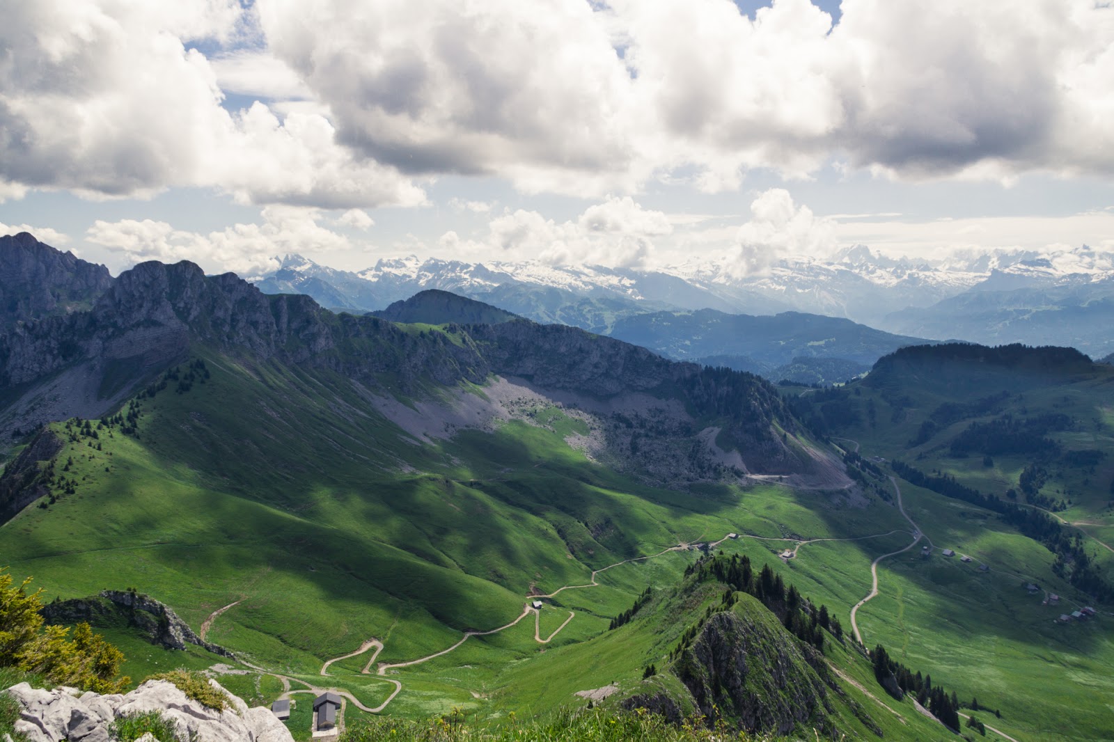
Tour of 3 summits: Chalune – Chavasse – Haute Pointe (2116m)

Today’s hike is special because I am doing not one – not two – but three different peaks. Pointe de Chalune is already known to us as Radek made a try to claim it in winter with a pair of our friends (see here). Haute Pointe was on my winter to do list but I chickened out at the very last moment and decided to go for something easier. So now – my try in summer for these mountains.

First on: Haute Pointe (1958m)

From there we wanted to traverse the ridge straight on to Pointe de Chavasse (2012m) but we were not sure if it was doable (it was – I checked later) and chose the longer route that was also on our maps.

Last on the list: Pointe de Chalune (2116 m)
The weather turned bad and we needed to race with the clouds and thunders we heard not far from us. Fortunately, we won!

Colomby de Gex (1688m)

This was our last weekend before a long trip to Poland so we didn’t feel to motivated for big trips but we still wanted to squeeze in a hike. In such cases Jura is always a good solution. You drive 15 minutes and you’re at a starting point so this saves a lot of fuss. We started from Col de la Faucille and continued more or less without a plan.

We soon reached Mont Rond from where we had a well known lovely Balcon du Leman view. It is familiar but never ceases to please us.

We decided to go along the ridge not knowing exactly what’s ahead but let’s face it – Jura is no Alps. We won’t get caught in rocks or crevasses 🙂 In the end we reached Colomby de Gex, had one last look over Mt Blanc and decided to head back to the car.

Le Moléson (2002 m)

Holidays are over… High time to go back on the trails. I didn’t choose the itinerary for today, I guess I would have been less courageous myself 🙂 But Moléson was the mountain I had always wanted to hike. It’s just beside Gruyeres, my beloved village that I visit several times every year. Every time I was there I looked at the lonely peek with a sparkle in my eye. So when there was an opportunity to join a hike there I didn’t hesitate.

Although we’ve had good weather this year, it’s still April so mountains are still in snow. We learnt about it in a pretty painful way. Wet and heavy ground slowed us down, we had problems finding the path and most of all, we were constantly sliding. Some passages would not pose any difficulty in summer but today they were delicate and it even happened to Sergey that he lost the grip and slid down a couple of metres. Fortunately, he was able to somehow stop and nothing serious happened.

Not without a struggle, but we made it to the top from where we had a nice panorama over the Alps. The sky was clouded but clouds were high enough to let us see far and well. We made a lunch break, happy and not aware that even more struggle ahead of us 🙂
Whenever I can, I always do the routes that go in loops, I don’t like to trace back my footsteps on my way down. Today was no different. What I didn’t know was that the variant that was chosen for our descent was not really used in winter. At least we didn’t see any traces of hikers. It looked like the opening walk for these chemins and now I see why.
The path led on a ridge of a neighbouring mountain that looked like that:

I don’t have that much experience in winter hiking so I didn’t trust this overhanging snow. In fact, if it wasn’t for Sergey who went first and encouraged us to continue, I would have turned back. I did this passage with my heart in my mouth and felt seriously relieved when it was over. The rest of the route was substantially easier but not really a Sunday walk either. To cross all the snow fields was not an easy task and we moved rather slowly at times. At some point we lost the path and had to go downhill in the snow. I was glad we made it safely to our car.

Sardinia Day 5: Tiscali

The very same day we went to visit Gorroppu canyon, we rushed up to the neighbouring Tiscali site. We were a bit tired after marching down and up and all the bouldering we did, nevertheless we wanted to see the so-advertised Tiscali site.
Tiscali is an ancient and pretty mysterious nuraghic site that dates back to the 6th century BC. Noone knows exactly why people settled in so high in the mountains but the remains of their village are to be seen up to this day.
Hiking to Tiscali was pretty easy and not too long with parts completely flat so we had a pretty good pace. The views were nothing fantastic to me but I’m spoiled by the Alps. On our way up we went past yet another archaeological gem – Domus de Jana – which looked like a cave shelter for someone pretty small. It was hidden among blossoming flowers and turpentine trees – a Flinstone-like look indeed.

To be honest, the site disappointed me greatly. I’m not an archeology lover, perhaps Andrzej Pilipiuk would have liked it better, but to me it was a bit boring and the fact they made me buy a ticket to see this was rather upsetting. The remains of the village are scarcely visible as all of the interesting stuff has been destroyed by raiders. The cave wall was nice but not worth 5 EUR. I also liked the twisted trees and the overall eery atmosphere of the place (no light, trees like ents etc) but I wasn’t blown away as I had thought I would be. Too bad.

Sardinia Day 5: Gola Su Gorroppu hike

The next day of our Sardinia trip was so action packed that i decided to split it to two posts. We were spending the day alone and the weather was good so we were able to squeeze in two hikes. We started from a Sardinia must – Gola Su Gorroppu Canyon.
This was a truly mesmerising hike first down to a canyon and then through the boulders and vertical walls of Su Gorroppu. We started from Silana hotel from where we continued a couple of kilometres down. It’s not often that you start hiking down, it’s quite tricky because you always need to keep powers to return to your car. In any case, the route to get to the canyon was already a nice walk.

We reached the entrance pretty early in the morning which was a good thing to do as later it became hotter and super crowded. The route is divided into three parts – easy, medium and difficult. The last one is advisable to be done with a guide and equipment. I’ll get to that soon 🙂

Even the easy part was already a fun scramble. We soon reached the famous 500 m climbing wall (that has the toughest climbing grade: 8b something – I’m not a prof on that). That was enormous and truly unbelievably beautiful. I felt like on shoot of Avatar movie with its fairylands. The two photos below show it best – can you see how small we are in the perspective?

We continued along the route and soon reached the red trail. We decided to keep on going as long as we manage. There was a couple in front of us that did the same, all the other tourists backed away as it really became super technical. In fact, I wouldn’t have made it alone, it was only thanks to Radek that was tall enough to reach certain ledges and later pull me up that I made it to the end. After a while we paired up with the other couple and continued together in joint efforts. It was seriously difficult at times, but nothing dangerous at least – no exposed places, no heights… When we reached the end of the canyon I was actually disappointed and was hoping for more. Pointe Percee – I am going to get you this year! 🙂

And the end:

We don’t have many photos from the red part of the trail as we needed our hands constantly but the ones we have show the deal 🙂 I recommend visiting this place with all my heart.

Sardinia Day 4: Punta la Marmora (1832m) and Su Barone Orosei


Happy Easter everybody! We’re spending this day by doing what we love the most – hiking. I mean, you saw it coming, right? Being on Sardinia and not to hike the highest mountain on the island? Naaaah 🙂
Punta la Marmora (1832 m) was supposed to be a walk in the park for us. Surprisingly… We didn’t make it to the top! You didn’t see this coming, right? I didn’t at least!

When we arrived at the car park it was below 0°C and the trail was covered with snow. We were below 1600 m over the sea level and the conditions were already bad. But OK, we enwrapped ourseleves with whatever at hand and set off on an adventure.
Almost immediately we started struggling with snow, cold and wind. In the beginning it was not too bad but with time the conditions became more and more difficult. Radek suffered from cold as he didn’t take his head band and needed to improvise by tying his shirt around the ears. I was lucky to have my gloves in the pocket.

We hiked below the ridge of the mountain, a bit on a side and the wind was already very very strong. When we reached a col the wind was almost unbearable. I needed to lean in against it so that I’m not knocked down. It was extreme, but terrain in this place was wide and safe so we decided to go past the col and continue on the side until we are closer to the top. But this plan didn’t work for long. The wind got only worse as we proceed and well, if you wanna reach the summit eventually you will have to hike up the ridge somewhere. When this moment came Radek went ahead to check out the conditions. He was like 10 meteres above me, crouching at the ridge and clinging to some rocks. I watched him struggling with wind and shouting to me something but I couldn’t hear a word. I was fighting myself not to be knocked down by the wind, I can’t imagine what it was like at the ridge. He showed me to turn back but I was afraid to move alone so I asked him to come down to me. He took a path behind the rock and for a minute or two I didn’t see him and it felt awful. Fortunately, he rejoined me after a moment and said that he hadn’t been able to stand up on the ridge due to very strong wind and we have no other choice to turn back. Well, it doesn’t happen often and I surely didn’t expect it on a T2 hike on Sardinia! But it was an extreme experience for us and I took the lesson that one should always be humble in mountains because in the end it’s often the mountain that decides if you will be able to reach the summit or not.

As we reached our car it started to rain and the weather stayed unsure untill the end of the day. In the evening we ventured a walk on the Su Barone Orosei beach where we took a couple of wet drops on our heads but nothing too serious.

Tete de Bostan (2406 m)

Our first big hike this season -Tete de Bostan. We’re gaining elevations gradually, 2406 m is already pretty high up so I can’t wait for the rest of the season to see if we are able to beat our record. I saw photos from Tete de Bostan on my friend’s FB and immediately decided I wanna go there. I knew it would be a challenge with nearly 1400m of elevation gain but couldn’t resist anyway. Especially after our previous hike that was not very satisfactory when it comes to length.

Before having challenged the mountain, as usual I checked the opinions and conditions on route. One guy wrote: „It sure is one long ridge”. I seriously can’t argue with that! This mountain has like 3 false summits! You think it’s there, you can see your destination, you’re approaching with the rest of your powers only to learn that it’s not there and you have like another hundred of meters to cover. A bit annoying 🙂 For example look at the photo below where I am pointing to what turned out not be our destination and Radek pointing to the real Tete de Bostan.

We had a very nice weather that day. The sun was frying us and we got some really nice tan despite having put factor 50 of sun block 🙂 And the views were rewarding throughout almost all of the hike.

Final meters were tough to me but I was making a steady progress because I was curious of the vertigo-building line right before the summit (see photo below).

We were right on time on the top as soon after we did some photos the weather changed and became clouded. Going down was frustrating. We shared our route up with lots of ski tourers and every time I saw them I was envy they had skis and I didn’t. I mean, I know I probably don’t have enough skill to ski down such a slope but it would have made everything so much easier! I have no doubts that ski touring will become my thing soon! But for now – long and tedious way down on snowshoes.

Sledging at Petit Mont Rond (1533 m)

It’s already winter in mountains. Maybe not too fierce one but there’s enough snow to go sledging with our baby boy. We decided to hike to a neighbouring Petit Mont Rond which was more of a walk to us. Starting from Col de la Faucille where there was snow already, we mounted our little one on a sledge and followed the now unused ski pistes.

The day turned out to be pretty favourable for our outing. Although the skies have been covered with clouds, every now and then we had a sun spell that would cover the world with a nice yellow glow.

When we reached the top we were stunned by the view. Clouds were high enough not to cover the Alps chain so we saw all of it! Spectacular.

After a while of photo taking, nature gazing and snow play, we went down on a sledge ride. It’s way faster than the way up 🙂

Pointe de Tardevant (2501 m)

This weekend Ania planned the last hike before a trip to Poland and maybe even last in this season. She gathered a group of people and prepared for starting early Saturday. Unfortunately she got sick during night and she passed the torch to me.

We started climbing to our first destination – Lac de Tardevant (2110m) where we made a small stop for pictures.

Together with Ania we have hiked a lot this summer but we never had a perfect weather with perfect visibility. This October hike was the firs this year when for all day long there was no even a smallest cloud.  

We had the perfect view – from Mt. Blanc to Jura. Hiking with such conditions is pure pleasure, especially that even though we had full sun it was not hot.

After year of hiking I felt in Haute-Savoie Alps like in home. I was able to recognize lots of peaks around me and that feeling that I hiked lots of them was awesome 😉

Lac Blanc et Lac des Chéserys (2352 m)

I am feeling that these might be the last days to go hiking this season for me so I am trying to use the time I have. With two other colleagues I drove past Chamonix to do a must-do route (yet another one!). I know this place is very crowded in high season so I waited until autumn to visit it. There were still quite some people but nothing too bad. The surroundings were not new to me as only a couple of weeks earlier I did two routes close by.

We soon reached Aiguillette d’Argentière – two spiky tops – that started a fun scramble to the lakes through chains and ladders. It’s always a very efficient way to hike because the more vertical you move the faster you get to the top. This time we moved very vertical.

When we finished the ladders section we found ourselves on a beautiful mountain plateau full of the most amazing autumn colours and a view on Mer de Glace glacier. Trully stunning.

I accidentally changed our planned route (yeah, I’m not a master of navigation) and we reached Lac des Chéserys first. I kind of thought it was our destination point so we made a pause there to have a bite and bask in the sun.

I was surprised to learn we still have some meters up to cover but I was also content to have additionals steps ahead. When we reached it,  the White Lake and it’s surrounding tops were in clouds making for a mystic ambiance.

We descended through a different path but the views were more or less similar. We quickly went out of the cloud and benefited from the sun rays. Have I mentioned I love autumn in mountains?